
Channel 6 Floodplain Map Update Project
The City has planned improvements that will reduce the flood risk to structures along Channel 6 and segments of the I-5 Canal and Q Street Canal that connect Channel 6 to the Willamette River. In order to make the improvements, the City must first amend the 1985 floodplain map panels currently on file with the Federal Emergency Management Agency (FEMA). Additionally, new technology is now available to more accurately map the specific floodplain for an area.
Detailed maps and technical analysis of the proposed floodplain map updates are available below for review. The maps and analysis can also be reviewed in-person from 8 am to 4 pm, Monday through Friday, at the Development and Public Works Department in the southeast wing of Springfield City Hall located at 225 Fifth Street in Springfield.
Check out the Questions & Answers and Interactive Map to learn more.

Project Update
In fall 2016, the City submitted an application to update the data and floodplain maps currently on file with the Federal Emergency Management Agency (FEMA). On June 1, 2017, FEMA confirmed that the analysis submitted by the City in fall 2016 is accurate. FEMA’s decision on the Letter of Map Revision will become effective on October 17, 2017. Any request to FEMA to reconsider the determination must be based on scientific or technical data and may be submitted directly to FEMA. Read the FEMA LOMR Decision Notification Letter.
Resources
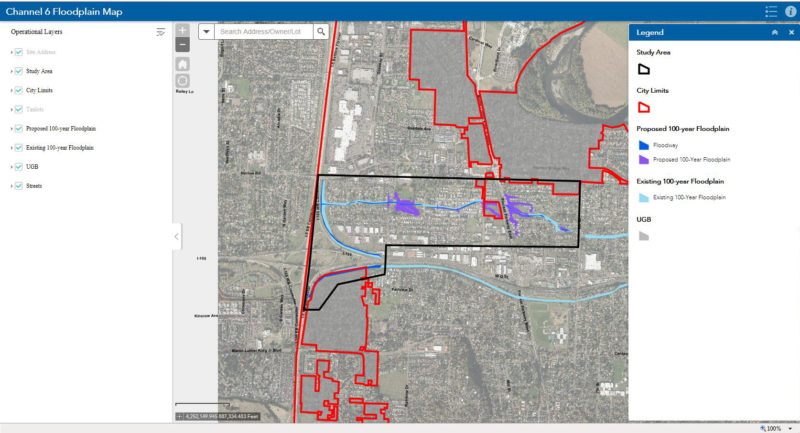
Interactive Map
Click on the map to view the existing and proposed floodplain map boundaries on individual properties.
Contact Us
For questions about your property:
City Floodplain Administrator
Jim Donovan
Planning Supervisor
541.726.3660
jdonovan@springfield-or.gov
For questions about the mapping and data collection:
Floodplain Mapping Project Manager
Molly Markarian
Senior Planner
541.726.4611
mmarkarian@springfield-or.gov